


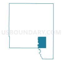
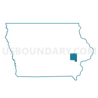
PLEASANT VALLEY TWP Voting District, Johnson County, Iowa
About
Outline

Summary
| Unique Area Identifier | 582495 |
| Name | PLEASANT VALLEY TWP Voting District |
| County | Johnson County |
| State | Iowa |
| Area (square miles) | 25.29 |
| Land Area (square miles) | 25.06 |
| Water Area (square miles) | 0.23 |
| % of Land Area | 99.08 |
| % of Water Area | 0.92 |
| Latitude of the Internal Point | 41.56043520 |
| Longtitude of the Internal Point | -91.48899560 |
Maps

Graphs
Select a template below for downloading or customizing gragh for PLEASANT VALLEY TWP Voting District, Johnson County, Iowa


Neighbors
Neighoring Voting District (by Name) Neighboring Voting District on the Map
- EAST LUCAS SOUTH PCT, Johnson County, IA
- FREMONT TWP Voting District, Johnson County, IA
- HILLS W/LIBERTY TWP & WEST LUCAS TWP PARTS Voting District, Johnson County, IA
- IOWA TWP Voting District, Washington County, IA
- LIBERTY TWP PART W/O HILLS Voting District, Johnson County, IA
- LINCOLN TWP Voting District, Johnson County, IA
- SCOTT TWP W/O WEST BRANCH Voting District, Johnson County, IA
Top 10 Neighboring County Subdivision (by Population) Neighboring County Subdivision on the Map
- West Lucas township, Johnson County, IA (8,152)
- Iowa township, Washington County, IA (2,262)
- Scott township, Johnson County, IA (2,144)
- Fremont township, Johnson County, IA (1,743)
- Liberty township, Johnson County, IA (1,104)
- East Lucas township, Johnson County, IA (551)
- Pleasant Valley township, Johnson County, IA (269)
- Lincoln township, Johnson County, IA (205)
Top 10 Neighboring Place (by Population) Neighboring Place on the Map
Top 10 Neighboring Unified School District (by Population) Neighboring Unified School District on the Map
- Iowa City Community School District, IA (105,355)
- Highland Community School District, IA (3,719)
- Lone Tree Community School District, IA (2,461)
Top 10 Neighboring State Legislative District Lower Chamber (by Population) Neighboring State Legislative District Lower Chamber on the Map
- State House District 78, IA (32,351)
- State House District 89, IA (31,869)
- State House District 79, IA (30,646)
Top 10 Neighboring State Legislative District Upper Chamber (by Population) Neighboring State Legislative District Upper Chamber on the Map
- State Senate District 39, IA (62,131)
- State Senate District 40, IA (60,420)
- State Senate District 45, IA (60,365)
Top 10 Neighboring 111th Congressional District (by Population) Neighboring 111th Congressional District on the Map
Top 10 Neighboring Census Tract (by Population) Neighboring Census Tract on the Map
- Census Tract 105, Johnson County, IA (7,257)
- Census Tract 104, Johnson County, IA (6,758)
- Census Tract 9601, Washington County, IA (6,354)
- Census Tract 18.01, Johnson County, IA (4,920)